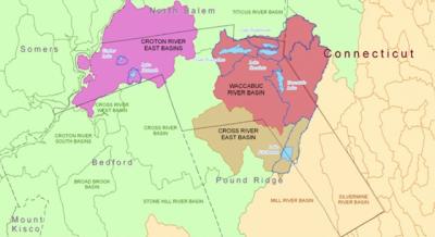
Lewisboro boasts seven residential lakes, each with its own distinctive character and active lake community. Together the households surrounding Lakes Waccabuc, Kitchawan, Truesdale, Oscaleta, Rippowam, Katonah, and Timber represent a significant constituency in the Town’s population. The lakes themselves are an important part of the Croton watershed, one of three major reservoir systems serving New York City’s 10 million residents. As such, Lewisboro’s lakes are not only a prized aesthetic and recreational resource, but a valuable contributor to the largest municipal water supply system in the United States.
|
More info about the Croton Watershed at: https://www.nyc.gov/assets/dep/downloads/pdf/whats-new/programs-initiatives/croton-watershed-delaware-aqueduct-shutdown-factsheet.pdf |
|
Lake |
Surface area (Acres) |
Max Depth (ft) |
Average Depth (ft) |
| Waccabuc | 140 | 46 | 23 |
| Kitchawan | 106 | 14 | 6 |
| Truesdale | 83 | 11 | 4 |
| Oscaleta | 67 | 35 | 19 |
| Rippowam | 37 | 19 | 13 |
| Katonah | 23 | 10 | 5 |
| Timber | 7 | 10 | 7 |
THREE LAKES
Lakes Waccabuc, Oscaleta and Rippowam are glacial lakes dating back to the Wisconsian ice age of 20,000 years ago. Located in the northeast corner of Lewisboro, the Three lakes, as they are dubbed, are interconnected by channels dug by the New York City Department of Public Works in 1877 in exchange for access to the lakes’ water supply.
In 1970, a group of neighbors interested in protecting and preserving the 2,200 acre watershed surrounding Lakes Waccabuc, Oscaleta and Rippowam formed the Three Lakes Council, which has become an award-winning resource in limnology education.
https://threelakescouncil.org/
In order of size, Lewisboro’s lakes are:
LAKE WACCABUC
Originally known as Wepac or Wequapaug in the Alqonquin language, Lake Waccabuc is the largest of the Three Lakes and the first to be settled by Europeans before the Revolutionary War. In 1857, the Waccabuc House resort opened as a weekend getaway for New Yorkers. Later summer camps and boathouses developed along the southern and northeastern shores. Today, there are approximately 200 homes around the lake and five neighborhood associations. Lake Waccabuc is approximately 140 acres in area with a maximum depth of 46 feet and a mean depth of 23 feet.
Lake Waccabuc Association was formed in 1949 by homeowners on the northeast shore to address issues of common concern, organize social activities, and maintain deeded rights-of-way to the lake. It numbers 112 households today.
Waccabuc Landowners Council is a volunteer organization formed in 1981 to maintain the unique character and beauty of Waccabuc (zip code 10597), the hamlet along the southwestern shore of the lake. The WLC represents approximately 200 homes
South Shore Waccabuc Association is a cooperative community of 30 cottages on the southeastern edge of Lake Waccabuc, first settled as a fishing camp in 1913.
Perch Bay Association consists of 28 properties along East Ridge Road, Post Office Road and Perch Bay Road that have deeded access to Lake Waccabuc’s shoreline.
Lakeside Association comprises ten houses with deeded rights to a right-of-way gifted by the original owner to his neighbors in 1966.
LAKE KITCHAWAN
Lake Kitchawan is a spring-fed lake that straddles the border between Pound Ridge and Lewisboro, with more homes on the Lewisboro side. It is named after the tribe of Kitchawong Indians who lived between the southern end of Lake Kitchawan and the northern end of Trinity Lake. In 1925, about 1250 lots were laid out on narrow streets. Three years later the Lake Kitchawan Park Owners Club was formed with about 70 member homeowners. Today, Lake Kitchawan is home to more than 200 residences. It covers 106 acres with a maximum depth of 14 feet and an average depth of 6 feet.
Lake Kitchawan Association is the modern-day incarnation of the Lake Kitchawan Park Owners Club representing homeowners on the eastern (Lewisboro) side of Lake Kitchawan.
Lake Kitchawan Conservation Committee is a 501(c)4 non-profit dedicated to the preservation and maintenance of Lake Kitchawan, its lagoon system, and surrounding wetland areas.
TRUESDALE LAKE
Truesdale Lake was initially created in 1908 when wealthy landowner Theodore Van Norden dammed the outlet of Hoyt’s Pond to turn it and the surrounding marsh land into a lake, which he named after the hill overlooking it. Later, a further 42 acres to the south were purchased and flooded. Today Truesdale Lake encompasses 83 acres. Its maximum depth is 11 feet, and mean depth is 4. Truesdale Lake is surrounded by approximately 70 riparian (waterfront) houses and an additional 200 or so houses that have deeded lake rights to the lake through one of the lake associations.
Map: Truesdale Association Map
Truesdale Lake Property Owners Association encompasses 150 owners and nearly 200 parcels along the northern shores of Lake Truesdale.
Truesdale Estates Association comprises 85 owners covering nearly 200 individual deeded properties. Noted in yellow on the linked map.
Lovecross/Vreeland Association comprises 8 owners covering 10 different properties just off the eastern shore ot Truesdale.
LAKE OSCALETA
Lake Oscaleta is the middle of the Three Lakes with channels at either end connecting Waccabuc to its west with Rippowam to its north. Summer camp cottages (now winterized) first appeared in the early 1900s on Knapp Road along the south shore. Later, shortly after WWII, Twin Lakes Village was developed on the peninsula between Oscaleta and Rippowam. A glacial lake, Oscaleta is 67 acres in size with a maximum depth of 35 feet and a mean depth of 19 feet.
Oscaleta Lake Association (aka Knapp Road Association) represents 30-odd homeowners on Knapp Road along Oscaleta's southern edge. It pays for road maintenance and provides limited right-of-way access.
Two Lake Club includes roughly 110 homeowners on Twin Lakes Road, Orchard Drive, North Lake Circle, and Oscaleta Road who have deeded rights and restrictions according to their covenant of sale. The Club is a homeowners' association charged with managing the common beach property open to all residents of Twin Lakes Village. It also serves as a social organization.
LAKE RIPPOWAM
Rippowam is the smallest of the Three Lakes at 37 acres. Given the steep slopes along its northern rim, only the south side of Rippowam has houses, 25 in total, which are part of Twin Lakes Village. Rippowam’s maximum depth is 19 feet; its mean depth is 13 feet.
Lake Katonah
Lake Katonah, like Katonah village, took its name from a 17th-century sachem of the Ramapo Indians, Chief Catoonah. Dutch colonists settled the area in the late 1600s, followed by cattle and dairy farming after the Revolutionary War. ln 1926, developers dammed Lake Katonah, enlarging it from 8.5 acres to its present 23 acres. They laid out roads, subdivided the land, and built the clubhouse and several model homes, initially offered as summer cabins for New York City residents. Lake Katonah’s maximum depth is 10 feet, and its mean depth is 7 feet.
Lake Katonah Club was founded in 1928 to organize community-wide amenities and recreational activities for its 104 member households and preserve the lake and its surroundings.
TIMBER LAKE
Timber Lake is at the center of the Goldens Bridge Community Association, also known as The Colony, a not-for-profit community association founded in 1935. The Colony comprises approximately 150 acres, 17 of which have been set aside as “forever wild” for the community’s enjoyment. Timber Lake is a 7-acre lake with a maximum depth of 10 feet and an average depth of 7 feet.
Goldens Bridge Community Association comprises the 125 members of The Colony and organizes social activities, recreational sports, entertainment, a summer camp, and volunteer activities.

